GIS Technology: Innovation In Motion
The Greater New Haven Water Pollution Control Authority utilizes GIS technology
The Greater New Haven Water Pollution Control Authority (GNHWPCA or Authority) has worked closely with its operations staff and contractors to develop inspection, analysis, and reporting tools that help plan, mitigate and reduce risk as well as response times when unexpected events occur.
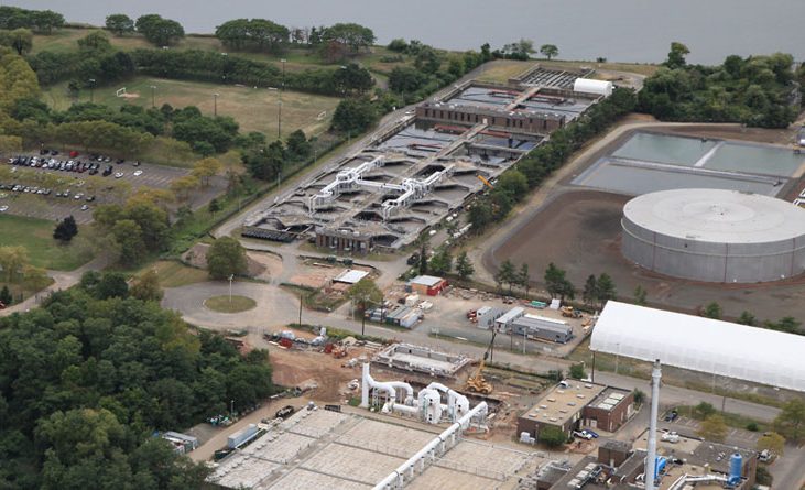
The GNHWPCA operates and maintains the wastewater system of the City of New Haven, and towns of Hamden, East Haven and Woodbridge. The City of New Haven is the only combined sewer system (CSS). In periods of heavy rainfall, total wastewater flows can exceed the capacity of the collection system and treatment facilities. When this occurs, the CSS is designed to overflow directly to surface water bodies. These overflows are called combined sewer overflows (CSO). In 2001, the City of New Haven published its comprehensive CSO long-term control plan as part of its requirements to comply with EPA’s Clean Water Act mandates. The plan included developing its GIS to assist in the creation of a hydraulic model, perform pipe risk assessments and prioritize inspections and rehabilitation projects.
Building a System of Record for Sewer Utility Assets
The Authority partnered with Langan Engineering and Environmental Services LLC (Langan) to help centralize its GIS data. Today, the GNHWPCA utilizes ArcGIS to manage 600+ miles of sewer pipes and link to data feeds and sources like video captures from CCTV cameras. ArcGIS supports goals to improve planning for flooding and overflow events, respond quickly and effectively to Call-Before-You-Dig 811 calls, reporting unplanned events like accidental line breaks and capital planning in support of new construction.
“The flexibility of Esri’s configurable web application tools like Experience Builder, along with ArcGIS Dashboards have dramatically reduced the time it takes for us to provide GNHWPCA with helpful decision support maps and apps.” said Tony Yates, Associate Principal/VP of Langan.
Maps and Apps Make an Impact
Staff at GNHWPCA use a variety of GIS-based web and mobile applications to monitor and maintain the health of the regional sewer system and integrated utility network. This includes:
- An integrated utility network, to enable mitigation of CSOs.
- ArcGIS Pro analysis tools that assist engineers and planners with site plan reviews and hydraulic modeling.
- The integration of sewer maps with incoming ticketing request and notification system, resulting in a nearly 100% reduction in “truck rolls” in response to damage events.
- Mobile tools (ArcGIS Survey123 and Field Maps) assist inspectors locating and assessing the condition of sewer infrastructure.
- The ability to see where to focus CCTV camera inspections and using results to determine the best repair or rehabilitation technology, supporting planning/budgeting.
- The ability to monitor tree roots and potential for root intrusion, determining the best treatment options, and monitoring preventative maintenance activities.
- Monitoring and recording the amount of FOG (fats, oils and grease) in pipes and visualizing the relationship between the location of build-up and potential contributors.
For each example above, Ricardo Ceballos, Senior engineer and GIS manager, underscored tasks that once took hours or days can now be completed in less than an hour. “We are continuously finding new ways to streamline our business workflows and deliver easy-to-use decision support solutions for our stakeholders,” said Ceballos.
Growing the Impact of GIS
The GNHWPCA is growing the value of GIS by integrating Esri’s network management capabilities with the customer information system (CIS) to take advantage of ArcGIS Utility Network traces that show impacted customers and trigger automated notifications. “This is especially important for notifying facility operators responsible for hospitals, schools and businesses as well as individual residents,” stated Ceballos.
The GNHWPCA team is also implementing new cartographic methods for symbolizing assets. This is especially significant for manhole cover junctions where it’s important to symbolize these junctions to reflect the real world where pipes meet the manhole wall (not the center of the manhole). GNHWPCA is also planning to explore ArcGIS Indoors as a solution to map the detailed interior spaces of large pumping stations and the wastewater treatment plant. ArcGIS Pro Flood Analysis tools will also be reviewed.
“Esri’s Utility Network Management tools are opening new options for both maintaining GNHWPCA’s expanding sewer infrastructure network as well as the tools needed to improve service to the GNHWPCA communities,” said Yates.

By Christa Campbell. She is the Director of Esri’s Water Industry team. She can be reached at CCampbell@esri.com .